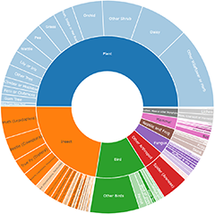
O'Connor Ridge to Gungahlin Grasslands sightings

The O'Connor Ridge to Gungahlin Grasslands corridor, via Lyneham Ridge and the much of the connected green spaces within Kaleen, is an area which may be important for north-south connectivity between the Inner North and Belconnen Districts for a range of ecosystem types. It forms an important linkage between a series of protected woodlands to the south, and a series of protected grasslands to the north, and also forms part of the catchment of Ginninderra Creek. 

Moderators

Become the first moderator for O'Connor Ridge to Gungahlin Grasslands

Become a moderator

Page 1 of 1 - image sightings only

No sightings currently exist.

O'Connor Ridge to Gungahlin Grasslands
  • Area (hectares) 318.96 ha
  • Survey Effort Score (SES) 12.72 sightings per ha

Follow O'Connor Ridge to Gungahlin Grasslands

Receive alerts of new sightings

Subscribe

Filter

Other Invertebrates

Share location

Share link to O'Connor Ridge to Gungahlin Grasslands field guide

How can I use location QR codes?

2,154,471 sightings of 19,955 species in 6,503 locations from 11,461 contributors
CCA 3.0 | privacy
We acknowledge the Traditional Owners of this land and acknowledge their continuing connection to their culture. We pay our respects to their Elders past and present.